CWMS LOCATION LEVELS
Overview. CWMS location levels are named objects that store numeric values related to specific locations and parameters. Unlike CWMS Time Series, which can also be described as above, normal location levels can be constant in time, vary in time in a repeating pattern, or vary irregularly in time by being associated with an actual time series. In addition, virtual location levels can be defined as transformations (ratings or formulas) applied to inputs (location levels or time series). All location levels have defined beginning date/time values (effective dates) and may or may not have ending date/time values (expiration dates). Levels of the same category (normal or virtual) may have the same name (identifier) but different effective dates. In this case, each level is in effect from its effective date until its expiration date (if any) or the subsequent level’s effective date, whichever is earlier (the level’s effective timespan). Levels of different categories may have the same identifier and overlapping effective timespans. The API routines to retrieve location level values for a specified time window can specify of the precedence of categories to retrieve the values for, with the default value being to retrieve virtual location level values if they exist and fall back to retrieving normal location level values otherwise. In this way, one category of location level can override a location level with the same identifier but different category. Each CWMS location level may have an attribute defined by a name (identifier) and a constant value. Location levels with the same level identifier, same attribute identifier, but different attribute values can be used to define guide/rule curves. CWMS location levels can also have associated indicator names, each of which can have up to five indicators, each of which is set (on/true) or unset (off/false) based on a specified logical expression (condition) of a specified time series and the location level value. This document describes CWMS location levels.
Location level Categories. All CWMS location levels are in one of the following categories. Each category will be discussed in more detail below.
Normal. Normal location levels are defined with actual values or references to time series with actual values.
Virtual. Virtual location levels are defined as transformations on actual values or time series.
Location levels in the same category with the same location level key (See section 6 below) but different effective dates supersede one another. Location levels in different categories with the same location level key may override one another, depending on the precedence specified in the routine to retrieve location level values.
Specified Levels. Each CWMS location level identifier includes an item called the specified level. A specified level is simply a name/identifier and is itself not associated with any location or parameter. The CWMS database pre-defines several specified levels, and each office can define its own if it has need to do so (256 characters maximum).
The pre-defined specified levels are:
Specified Level |
Description |
|---|---|
Bottom of Exclusive Flood Control |
Bottom of Exclusive Flood Control Level |
Bottom of Flood Control |
Bottom of Flood Control Level |
Bottom of Inlet |
Bottom of Inlet Level |
Bottom of Multi-Purpose |
Bottom of Multi-Purpose Level |
Bottom of Normal |
Bottom of Normal Level |
Bottom of Operating |
Bottom of Operating Level |
Bottom of Power |
Bottom of Power Level |
Design Capacity |
Design Capacity Level |
Flood |
Flood Level |
Max Non-Damaging |
Maximum Without Causing Damage Level |
Regulating |
Regulating Level |
Streambed |
Streambed Level |
Top of Conservation |
Top Conservation Level |
Top of Dam |
Top of Dam Level |
Top of Downstream |
Top of Downstream Level |
Top of Exclusive Flood Control |
Top of Exclusive Flood Control Level |
Top of Flood |
Top of Flood Level |
Top of Inactive |
Top of Inactive Level |
Top of Induced Surcharge |
Top of Induced Surcharge Level |
Top of Inlet |
Top of Inlet Level |
Top of Multi-Purpose |
Top of Multi-Purpose Level |
Top of Normal |
Top of Normal Level |
Top of Operating |
Top of Operational Level |
Top of Outlet |
Top of Outlet Level |
Top of Overflow |
Top of Overflow Level |
Top of Power |
Top of Power Level |
Location Level Identifiers. Location levels apply specified levels to specific combinations of location, parameter, parameter type, and duration, with an optional attribute (see Section 5 below). CWMS location level identifiers join these various parts – minus the attribute – together using the dot character (‘.’) as a separator after the fashion of the CWMS time series identifiers, as shown:
+————————– Location
| +——————— Parameter
| | +—————- Parameter Type
| | | +———– Duration
| | | | +——— Specified Level
| | | | |
| | | | |
—- —- —- - ——————-
KEYS.Elev.Inst.0.Top of Conservation
KEYS.Stor.Inst.0.Top of Conservation
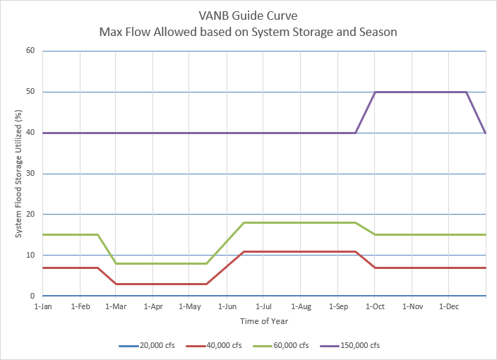
Location Level Attributes. Attributes provide means of building guide/rule curves from CWMS location levels. Attributes are defined by an identifier and a value. The attribute identifier comprises a parameter, parameter type and duration, joined together using the dot (‘.’) character. The attribute identifier describes the attribute value. An example location level identifier with an associated attribute identifier is shown below. In this example, the guide curve is used to determine the maximum flow allowed at a location based on the percent of basin storage used and season of year. The guide curve is made from four seasonal (regularly varying) normal location levels with attributes of 20,000, 40,000, 60,000, and 150,000 cfs.
+————————————– Location
| +——————————— Parameter
| | +—————– Parameter Type
| | | +————- Duration
| | | | +—— Specified Level
| | | | |
| | | | |
—- ————— — —— ———–
VANB.%-of Basin Full.Ave.6Hours.Guide Curve
+————– Attribute Parameter
| +——— Attribute Parameter Type
| | +—– Attribute Duration
| | |
| | |
—- — ——
Flow.Max.6Hours
Location Level Keys. For the purposes of the remainder of this document, a location level key comprises:
Location Level Identifier. Required.
Attribute. Optional, both or neither of the identifier and value must be null.
Attribute Identifier.
- Attribute Value. In the API routines, the attribute value
is specified by a numeric value and a unit.
Common Metadata.
Level-Specific Metadata. The following items are defined for each level when storing location levels. They are not shared by different location levels that have the same location level key.
- Effective Date. Each location level is required to have an
effective date. The value of the location level is as defined on or after this date/time. The value of the location level is undefined before this date/time. The effective date provides the ability to have a sequence of location level definitions for the same category and key.
- Expiration Date. Each location level may have an expiration
date. The value of the location level is as defined before this date/time and undefined on or after. If present, the expiration date must be later than the effective date. Since this item belongs to an individual level, having another level with the same category and identifier and an effective date earlier than this level’s expiration date will make the expiration date meaningless as the location level value would be for any time on/after the expiration date would be provided by the subsequent level.
- Level Comment. Each location level may have a comment of up
to 256 characters describing the level.
- Attribute Comment. location levels with attributes may have
a comment of up to 256 characters describing the attribute.
Key-Associated Metadata. The following optional items are associated with location levels by location level key. They apply to levels of any category or effective date with the associated key.
- Sources. Each location level may be associated with a
source entity that is responsible for the definition of the level. The CWMS database pre-defines 141 entities which include USACE offices, NWS offices, EPA, FEMA, NOAA, NRCS, USBR, USGS, US states, power marketing administrations (APA, BPA, SEPA, SWPA, TVA, & WAPA), as well as one for unknown/unspecified. In addition, offices can add other entities if necessary.
- Indicators. Each location level may be associated with one
or more sets of indicators, each set of which may be used to indicate the status of a time series with respect to the location level. location level indicators are described in detail below.
Normal Location Levels. Each normal location level is a constant level, a regularly varying level, or an irregularly varying level.
Constant Levels. A constant location level specifies a single value that is constant for the effective timespan of the location level.
Regularly Varying Levels. Also called seasonal or periodic levels, each regularly varying location level specifies a repeating pattern of values by defining the following.
- Interval. Either calendar-based or time-based timespan that
defines the pattern repetition period. A calendar-based interval is one specified in terms of years and/or months; a time-based interval is one specified in terms of days and/or smaller units. The typical interval is one year, as many USACE reservoirs have operating plans that repeat on a yearly cycle, but any interval can be used to suit the purpose of the location level.
- Interval Origin. The interval origin specifies a starting
date/time of any interval. For instance, a calendar year interval and a water year interval would both be specified as 1-year intervals, but the calendar year interval would have an interval origin of 00:00:00 on January 1st of some year, while the water year interval would have an interval origin of 00:00:00 on October 1st of some year.
- Seasonal Values. The location level values at two or more
offsets into the interval. Each seasonal value includes:
Offset Months. The calendar-based component of the offset.
Offset Minutes. The time-based component of the offset.
Value. The location level value at the offset into the interval.
The start of the current interval for a date/time is computed by adding or subtracting the interval to/from the interval origin until the latest interval start on or before the date/time is found.
The offset date/time is computed by adding the offset months to the start of the current interval and then adding the offset minutes to that.
For example, to find the date/time for an offset of 1 month and 20,880 minutes for a 1-year interval with an interval origin of 2000-01-01 00:00 and the date/time of 2022-03-01 07:00, the interval origin is incremented by the interval 22 times, yielding 2022-01-01 00:00, which is then incremented by 1 month, yielding 2022-02-01 00:00 and then 20,880 minutes, resulting in 2022-02-15 12:00.
A common mistake is to set the offset months to the month-of-year of the offset date/time and to set the offset minutes based on the day-of-month of the offset date/time. Making this mistake with the above example (offset date/time = 2022-02-15 12:00) would have caused the offset months to be set to 2 and the offset minutes to be set to 22,320 (15 * 24 * 60 + 12 * 60). Since both the month-of-year and day-of-month begin with 1, using these values would have resulted in the offset date/time being 2022-03-16 12:00.
- Interpolate Flag. This determines what value is returned as the
location level value for a specified time that is between two offset date/times in the seasonal values.
True. The value returned is interpolated between the value at the previous offset date/time and the value at the next offset date/time.
False. The value at the previous offset date/time it returned.
Note that the seasonal values do not necessarily need to include values at the beginning and end of the interval. Any value returned for a date/time between the beginning of the interval and the first offset date/time will be determined using the value at the last offset date/time of the previous interval and the value at the first offset date/time of the current interval, as determined by the interpolate flag. Likewise, the value at a date/time after the last offset date/time and before the end of the interval will be determined using the value at the last offset date/time of the current interval and the value at the first offset date/time of the next interval.
Irregularly Varying Levels. Each irregularly varying location level specifies the following.
- Time Series Identifier. The identifier of a CWMS time series
existing in the CWMS database that provides the values for this location level.
- Interpolate Flag. This determines what value is returned as the
location level value for a specified time that is between two times in the underlying time series.
True. The value returned is interpolated between the value of the previous time and the value of the next time in the time series.
False. The value of the previous time in the time series it returned.
Note that unlike constant and regularly varying levels – which are always defined during the effective timespan – irregularly varying levels may be undefined for a portion (up to and including all) of the effective timespan because the associated time series may not have values for all that period.
Virtual Location Levels. Each virtual location level includes the following.
Constituents. Each virtual location level is computed from a set of constituents, each of which is either an input or a transform. Input constituents may be either other location levels or time series. Transform constituents are ratings or formulas. Each virtual location level requires at least one input constituent and one transform constituent, but complex virtual location levels may have more than one of each.
Each constituent as a type and name:
Type |
Name |
Example |
|---|---|---|
LOCATION_LEVEL |
Location Level Identifier |
Freemont.Elev.Inst.0.Top of Flood |
TIME_SERIES |
Time Series Identifier |
Freemont.Elev.Inst.0.0.rev-ccp |
RATING |
Rating Sp ecification |
Free mont.Elev;Stor.Linear.Standard.Step |
FORMULA |
M athematical Expression with Units * |
(ARG1 + ARG2) / 2 {ac-ft,ac-ft;ac-ft} |
*A mathematical expression (see Table 2: Mathematical Expression Components) followed by a units string. The units string is a comma-separated string of units for each argument followed by a semicolon and the unit of the result of the expression, all enclosed in curly braces (e.g., {arg1_unit,arg2_unit…;result_unit}).
In addition, each constituent has an abbreviation which is used in the connection string. The rules for constituent abbreviations are:
Must be 2-4 characters in length
The first character must be the same as the first character of the constituent’s type (i.e., ‘L’, ‘T’, ‘R,’ or ‘F’)
Normally, constituent abbreviations are simply the required first character appended with the order of the constituent’s type within the set of constituents (e.g., L1 for the first LOCATION_LEVEL constituent, R2 for the second rating constituent, etc.) but this is not required.
Connection String. Each constituent has one or more connection points which connect it to one or more of the other constituents. Input constituents have only one connection point, which is named the same as the constituent’s abbreviation. Transform constituents have a minimum of two connection points: they have one or more independent (normally input) connection points and one dependent (normally output). These connection points are named by appending I1, I2, etc… to the constituent abbreviation for independent connection points and appending D to the abbreviation for dependent connection points (e.g., R1I1, F2I1, R2D, etc…). Only when the transform constituent is a reversible rating (monotonic single independent parameter rating) can the dependent connection point be an input and the independent connection point be an output.
The connection string specifies one or more sets of connected connection points by placing them on either side of an equals sign character (‘=’). If more than one connection is required, the sets of connected connection points are separated by the comma character (‘,’). The connections string must connect every input connection point to the independent connection point of one or more transforms and must leave exactly one transform dependent connection point unconnected. Complex virtual location levels may connect input connection points or transform dependent connection points to more than one transform independent connection points. Some example connection strings are shown in Table 1: Example Connection Strings.
Location Level Indicators. Location level indicators are devices that indicate the status of time series values with respect to location levels. Each indicator can define up to five conditions against which to compare time series values. Each condition has a value in the range of [1..5] and a Boolean test. If the comparison for any condition yields a value of TRUE, the condition is considered to be set for the time series value. Condition tests need not be mutually exclusive, so a single time series value may set multiple conditions of an indicator. Regardless of mutual exclusivity, higher valued conditions are normally considered to be of greater importance or severity than lower valued conditions, so the API provides a routine to retrieve the maximum indicator values set.
Condition tests have an evaluation time and a tested value time.
The evaluation time is the specified time for the condition to be evaluated.
The tested value time may be earlier than the evaluation time. Only time series values that are not marked as missing or rejected are used in the tests, so the tested value time will be the time of the latest time series value not marked as missing or rejected that is on or before the evaluation time.
Location level indicators are identified by extending a location level key with an indicator name. A full location level indicator identifier is shown:
+————————————- Location
| +——————————– Parameter
| | +————————— Parameter Type
| | | +———————- Duration
| | | | +——————– Specified Level
| | | | | +——- Indicator
| | | | | |
| | | | | |
—- —- —- - ———— ————
KEYS.Stor.Inst.0.Top of Flood.PERCENT FULL
In this document, indicator identifier means the entire location level identifier as shown above, and indicator name means the last portion of the location level identifier (PERCENT FULL in the above example).
Each location level indicator has the following:
Indicator Name (Required). Maximum length of 32 characters. Upper case.
Location level key (Required). As noted above, location level indicators are key-associated with location levels. This allows an indicator to apply to a succession of location levels with the same key instead of being tied to any specific level within the succession.
Reference location level key (Optional). Location level indicators may reference a second location level, provided that the referenced level shares the same location, parameter, parameter type and duration with the associated location level. Only the specified level and/or attribute value may differ between the associated level and the reference level. This allows conditions to test the fraction a time series value represents within the difference of two levels. For example, a condition for an indicator associated with the location level KEYS.Stor.Inst.0.Top of Flood could reference the level KEYS.Stor.Inst.0. Bottom of Flood to use a time series of storages to determine what zone within the flood control pool they represent.
Minimum Duration (Optional). If unset or zero, only the tested value time is used. If set to greater than zero, the comparison is evaluated at the tested value time and all previous times within the Minimum Duration. The condition is set only if the evaluation at the tested value time yields TRUE and none of the comparisons at previous times yield FALSE. For example, if the minimum duration is set to 6 Hours while testing a 1-Hour interval time series, any comparisons that yield FALSE at the tested value time or previous five interval times causes the condition to be unset
Maximum Age (Optional). If unset or zero, there is no constraint on how far the tested value time precedes the evaluation time. Otherwise, if the tested value time is earlier that the evaluation time minus the maximum age, no comparisons are performed and no conditions are set for the indicator.
Conditions (Optional). Although an indicator with no conditions is not useful, the only constraints on conditions are that there can be no more than five, their values must be in the range [1..5], and only one condition per value is allowed.
Each condition evaluates a mathematical expression of the time series value V, associated location level value L (or L1) and possibly the reference location level value L2*. The result of the expression is then compared against a specified value using a specified numeric comparison operator+. Optionally, a 2nd comparison for the expression result (using a separate comparison value and separate numeric comparison operator) may be specified and combined with the 1st comparison via a specified logical connector$. The result of this process (with or without the 2nd comparison) yields a logical value (TRUE or FALSE) called the value comparison.
Additionally, each condition may specify a rate comparison, which is performed similarly to the value comparison (including an optional 2nd comparison and logical connector) except that the rate expression is an expression of the variable R and not V, L (or L1) and L2*. The rate comparison is only performed if the value comparison yields TRUE.
The indicator value for the condition is set as follows:
If a rate comparison is specified, the indicator value is set only if the value comparison and rate comparison both evaluate to TRUE; otherwise it is unset.
If no rate condition is specified, the indicator value is the result of the value comparison.
Each location level indicator condition includes:
Indicator Value (Required). An integer in the range of 1..5 inclusive
Value Expression (Required). A mathematical expression with special arguments V, L (or L1) and L2*
Value Comparison Operator 1 (Required). The comparison operator+ for the 1st comparison of the value comparison
Value Comparison Value 1 (Required). The comparison value for the 1st comparison of the value comparison
Value Comparison Connector (Optional). The logical connector for the 1st and 2nd comparisons of the value comparison
Value Comparison Operator 2 (Optional). The comparison operator+ for the 2nd comparison of the value comparison
Value Comparison Value 2 (Optional). The comparison value for the 2nd comparison of the value comparison
Rate Expression (Optional). A mathematical expression with special argument R*
Rate Comparison Operator 1 (Optional). The comparison operator+ for the 1st comparison of the rate comparison
Rate Comparison Value 1 (Optional). The comparison rate for the 1st comparison of the rate comparison
Rate Comparison Connector (Optional). The logical connector for the 1st and 2nd comparisons of the rate comparison
Rate Comparison Operator 2 (Optional). The comparison operator+ for the 2nd comparison of the rate comparison
Rate Comparison Value 2 (Optional). The comparison rate for the 2nd comparison of the rate comparison
*See Table 2: Mathematical Expression Components
+See Table 3: Comparison Operators
$See Table 4: Logical Connectors
** Typ e** |
Name |
A b b r * * |
C onn ect ion St rin g |
Ou tput Conn ecti on |
Description |
|---|---|---|---|---|---|
LO CAT ION _LE VEL |
Freemont.E lev.Inst.0.Top of Flood |
L 1 |
L 1=R 1I1 |
R1D |
Storage location level rated from elevation location level |
RAT ING |
Fr eemont.Elev;St or.Linear.Step |
R 1 |
|||
TI ME_ SER IES |
Freem ont.Elev-Upper End.Ave.6Hour. 0.Computed-ccp |
T 1 |
T1= F1I 1,T 2=F 1I2 |
F1D |
Elevation location level as average of two time series |
TI ME_ SER IES |
Freem ont.Elev-Lower End.Ave.6Hour. 0.Computed-ccp |
T 2 |
|||
F ORM ULA |
(ARG1 + ARG2) / 2 {ft,ft;ft} |
F 1 |
|||
LO CAT ION _LE VEL |
Freemont.E lev.Inst.0.Top of Flood |
L 1 |
L 1=F 1I1 |
F1D |
Elevation location level with imposed max value |
F ORM ULA |
MIN($I1, 1070.35) {ft;ft} |
F 1 |
Num bers |
||
|---|---|---|
1, 2.5, 3.2E-3 |
integer, floating point, or scientific notation |
|
Argum ents* |
||
ARG1, ARG2, … |
normalized argument form for generalized mathematical expressions (not indicator condition expressions) |
|
$I1, $I2, … |
alternate argument form for generalized mathematical expressions (not indicator condition expressions) |
|
V |
represents time series value in indicator condition expressions |
|
R |
represents the rate of change of the time series value V in indicator condition expressions |
|
L, L1 |
represents associated location level value in indicator condition expressions |
|
L2 |
represents reference location level value in indicator condition expressions |
|
Expr ession Oper ator |
||
(…) |
override order of o perations |
infix (algebraic) notation only, not used in postfix notation (RPN) |
Unary Oper ator* |
||
negation |
prepend to item without space, can used only on numbers and arguments (not expressions – use NEG for that) |
|
** Binary Opera tors** |
||
addition |
||
su btraction |
||
* |
multi plication |
|
/ |
division |
|
// |
integer division |
like python operator |
% |
modulus |
like python math.fmod(), not python % |
^ |
expon entiation |
|
Unary Funct ions* |
||
ABS |
absolute value |
|
ACOS |
arccosine |
|
ASIN |
arcsine |
|
ATAN |
a rctangent |
|
CEIL |
ceiling |
smallest integer >= argument |
COS |
cosine |
|
EXP |
ex ponential |
e raised to power of argument |
FLOOR |
floor |
Largest integer <= argument |
INV |
inverse |
1 / argument |
LN |
natural logarithm |
|
LOG |
base 10 logarithm |
|
NEG |
negation |
|
ROUND |
round to nearest integer |
|
SIGN |
signum |
sign of argument: -1 or +1 |
SIN |
sine |
|
SQRT |
square root |
|
TAN |
tangent |
|
TRUNC |
truncate to integer portion |
|
** Binary Funct ions** |
||
MAX |
maximum of two arguments |
|
MIN |
minimum of two arguments |
|
Const ants* |
||
E |
e |
Euler’s number |
PI |
π |
ratio of a circle’s circumference to its diameter |
Comparison Operators |
|
|---|---|
LT, < |
less than |
LE, <= |
less than or equal to |
EQ, = |
equal to |
NE, !=, <> |
not equal to |
GE, >= |
greater than or equal to |
GT, > |
greater than |
Logical Connectors |
||||||||||||||||
|---|---|---|---|---|---|---|---|---|---|---|---|---|---|---|---|---|
AND |
|
|||||||||||||||
OR |
|
|||||||||||||||
XOR |
|